Geospatial Data Standard & Pipeline
Overview
The GDR's geospatial data pipeline focuses on metadata rather than the data itself. It automatically recognizes geospatial data files using file extensions, and requires additional and essential metadata for geospatial datasets. It also provides suggestions for other useful geospatial metadata to provide in order to maximize reusability.
Tips to Ensure your Data are Standardized
To ensure your data are standardized, follow these tips:
- Do not put your geospatial data into zipped directories.
- Ensure that your geospatial data are in a compatible format:
- Data: Auto Cad Drawings (.dwg), USGS DEM (.dem), Floating Point Rater File (.flt), Comma-seperated file (.csv, .txt), GeoTIFF (.tif, .tiff), HGT (.hgt), ASCII Grid (.asc), Grid (.grd), Esri File Geodatabase (.gdb), Esri Layer File (.lyr), Geography Markup Language (.gml), KML - Keyhole Markup Language (.kml), GeoJSON (.geojson), LiDAR (.las, .laz, .zlas), Esri layer package (.lpk, .lpkx), NetCDF (.netcdf, .nc, .nc4), Geoparquet (.geoparquet), HDF5 (.h5).
- Maps: Portable document format (.pdf), tagged image file format (.tif, .tiff), joint photographic experts group (.jpeg, .jpg), graphics interchange format (.gif), bitmap (.bmp), portable network graphic (.png), support vector graphics (.svg), or photoshop document (.psd).
- Make sure to select 'Geospatal Data' from the 'File Type' dropdown menu if it does not automatically populate as such.
- Input all of the required and suggested metadata based on the CRS selected from the dropdown menu.
If you think your data were not standardized in error, please contact GDR Help. We are happy to assist and are constantly looking to improve are data standards and pipelines.
Helpful Resources
Here are some helpful resources related to the GDR's geospatial data standard and pipeline:
- GRC Paper on geospatial data pipeline - or request a copy from GDR Help.
- ISO 19115-1. “Geographic information — Metadata.”
- Geoparqet format - Recommended for big geospatial data
How Does it Work?
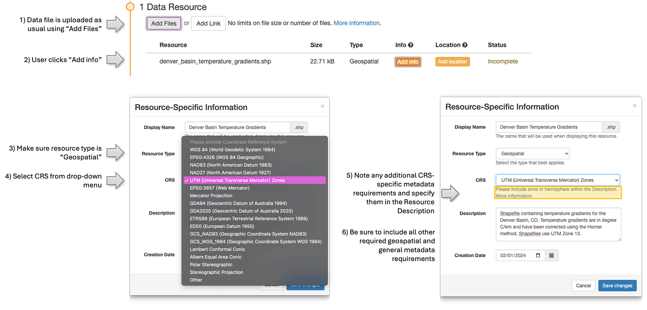
When a submitter uploads a geospatial data file in a recognized format to a GDR submission, the GDR will use its file extension to determine if it could be geospatial data. If “Geospatial Data” is selected from the drop-down menu, an additional required resource-specific metadata field will appear for the coordinate reference system (CRS). The user should select the correct CRS from the drop-down menu, and observe any additional, CRS-specific, required metadata attributes (will appear directly below the “CRS” field). These additional required metadata attributes should be included in the “Resource Description.” Users should also be sure to include all other required geospatial metadata attributes (see table below) and all other required general metadata attributes. The image below provides a visual depiction of this process.
The GDR Geospatial Metadata Standard
| Key Metadata Attribute and Description | Where to Include in the GDR Submission Form | Required* |
|---|---|---|
|
Identification Information
This includes the title, abstract, purpose, and status of the geospatial data, as well as any keywords that describe its content. |
Required input fields in the submission form | |
|
Data Quality Information
This includes information on the positional accuracy, attribute accuracy, logical consistency, and completeness of the geospatial data. |
Include in the submission abstract, resource description(s), or in a readme file. | |
|
Type of Geospatial Data
This includes an explanation of the type of geospatial data. For example, is the file geography data (e.g., a csv file with information about coordinates) or geometry data? If the file contains geometry data, is it vector (e.g., points, lines, or polygons) or raster data (e.g., a georeferenced map)? |
Include in resource description for geospatial data file. | |
|
Coordinate Reference System (CRS)
This includes information on the coordinate system, units, projection, and datum used for the geospatial data. |
Required selection from Resource CRS drop-down, which will automatically appear when user uploads geospatial data in a compatible format. | - |
|
Name of Geometry Column
If the geospatial data file contains columnar geometry data, the name of the column containing geometry information should be provided. |
Include in resource description for geospatial data file. | - |
|
Temporal Reference Information
This includes information on the time period of the data, such as the date of creation, publication, or last update. |
Required input fields for creation date and publication date in the GDR submission form. Include time period in the submission abstract, resource description(s), or in a readme file. |
|
|
Data Source Information
This includes information on the originator, publisher, and any other relevant sources of the geospatial data. |
Originator and publisher are required in the submission form, but any other relevant sources of the geospatial data should be specified in the submission abstract, resource description(s), or in a readme file. | |
|
Entity and Attribute Information
This includes information on the features, attributes, and attribute values present in the geospatial data, as well as any attribute definitions, domains, and units of measure. |
Include in the submission abstract, resource description(s), or in a readme file. | |
|
Distribution Information
This includes information on the format, size, and access methods for the geospatial data, as well as any fees, restrictions, or licensing requirements. |
"The format and size are automatically displayed for every data file in the GDR. Any specific access methods should be specified in the submission abstract, resource description, or an associated readme file." |
|
|
Metadata Reference Information
This includes information on the metadata itself, such as the date of creation, contact information for the metadata author, and any metadata standards or profiles used. |
"Required input fields for metadata creation date, contact information, and author(s) in the GDR submission form. Any metadata standards or profiles used which differ from the GDR's standards should be specified in the submission abstract, resource description, or in an associated readme file." |
|
|
Spatial Domain Information
This includes information on the geographic extent of the geospatial data, such as bounding coordinates or a description of the area covered. |
Required by the location attribute associated with each resource uploaded to a GDR submission. | |
|
Lineage Information
This includes information on the history of the geospatial data, such as the methods used for data collection, processing, and quality control. |
Include in the submission abstract, resource description, or an associated README file. | If history is relevant to use of the data |