Utah FORGE: Seismic Velocity Models, February 2021

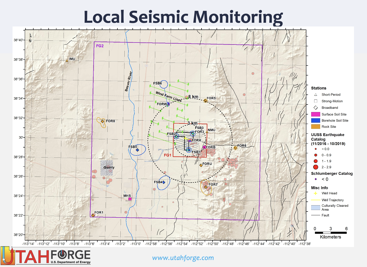
This dataset contains a map, showing the Utah FORGE seismic stations, and seismic velocity model data. There are 61 1-D velocity models which are in a compressed TAR file. A paper is referenced at the end of this description which discusses the use of these data in 3D modelling. The paper summary follows:
We expand the application of spatial autocorrelation (SPAC) from typical 1-D Vs profiles to quasi-3-D imaging via Bayesian Monte Carlo inversion (BMCI) using a dense nodal array (49 nodes) located at the Utah Frontier Observatory for Research in Geothermal Energy (FORGE) site. Combinations of 4 and 9 geophones in subarrays provide for 36 and 25 1-D Vs profiles, respectively. Profiles with error bars are determined by calculating coherency functions that fit observations in a frequency range of 0.2-5 Hz. Thus, a high-resolution quasi-3-D Vs model from the surface to 2.0 km depth is derived and shows that surface-parallel sedimentary strata deepen to the west, consistent with a 3-D seismic reflection survey. Moreover, the resulting Vs profile is consistent with a Vs profile derived from distributed acoustic sensing (DAS) data located in a borehole at the FORGE site. The quasi-3-D velocity model shows that the base of the basin dips ~22 degrees to the west and topography on the basement interface coincident with the Mag Lee Wash suggests that the bedrock interface is an unconformity.
Reference: Zhang, H. and K. L. Pankow (2021). High-resolution Bayesian spatial auto-correlation (SPAC) pseudo-3D Vs model of Utah FORGE site with a dense geophone array, Geophys. Res. Int,
https://doi.org/10.1093/gji/ggab049
Citation Formats
TY  - DATA
AB  - This dataset contains a map, showing the Utah FORGE seismic stations, and seismic velocity model data. There are 61 1-D velocity models which are in a compressed TAR file. A paper is referenced at the end of this description which discusses the use of these data in 3D modelling. The paper summary follows:

We expand the application of spatial autocorrelation (SPAC) from typical 1-D Vs profiles to quasi-3-D imaging via Bayesian Monte Carlo inversion (BMCI) using a dense nodal array (49 nodes) located at the Utah Frontier Observatory for Research in Geothermal Energy (FORGE) site. Combinations of 4 and 9 geophones in subarrays provide for 36 and 25 1-D Vs profiles, respectively. Profiles with error bars are determined by calculating coherency functions that fit observations in a frequency range of 0.2-5 Hz. Thus, a high-resolution quasi-3-D Vs model from the surface to 2.0 km depth is derived and shows that surface-parallel sedimentary strata deepen to the west, consistent with a 3-D seismic reflection survey. Moreover, the resulting Vs profile is consistent with a Vs profile derived from distributed acoustic sensing (DAS) data located in a borehole at the FORGE site. The quasi-3-D velocity model shows that the base of the basin dips ~22 degrees to the west and topography on the basement interface coincident with the Mag Lee Wash suggests that the bedrock interface is an unconformity.

Reference: Zhang, H. and K. L. Pankow (2021). High-resolution Bayesian spatial auto-correlation (SPAC) pseudo-3D Vs model of Utah FORGE site with a dense geophone array, Geophys. Res. Int,
https://doi.org/10.1093/gji/ggab049
AU  - Pankow, Kristine
DB  - Geothermal Data Repository
DP  - Open EI | National Laboratory of the Rockies
DO  - 10.15121/1776592
KW  - geothermal
KW  - energy
KW  - seismic data
KW  - 1D seismic velocity
KW  - seismic velocity
KW  - Utah FORGE
KW  - FORGE
KW  - Utah geothermal
KW  - velocity models
KW  - seismic
KW  - velocity
KW  - SPAC
KW  - spatial auto-correlation
KW  - pseudo-3D
KW  - geophone
KW  - Bayesian Monte Carlo inversion
KW  - modeling
KW  - model
KW  - distributed acoustic sensing
KW  - geospatial data
KW  - sedimentary basin
KW  - waveform inversion
KW  - seismic noise
KW  - geophysics
KW  - TAR
KW  - EGS
KW  - Roosevelt Hot Springs
KW  - Utah
KW  - Milford
LA  - English
DA  - 2021/02/28
PY  - 2021
PB  - Energy and Geoscience Institute at the University of Utah
T1  - Utah FORGE: Seismic Velocity Models, February 2021
UR  - https://doi.org/10.15121/1776592
ER  -
Pankow, Kristine. Utah FORGE: Seismic Velocity Models, February 2021. Energy and Geoscience Institute at the University of Utah, 28 February, 2021, Geothermal Data Repository. https://doi.org/10.15121/1776592.
Pankow, K. (2021). Utah FORGE: Seismic Velocity Models, February 2021. [Data set]. Geothermal Data Repository. Energy and Geoscience Institute at the University of Utah. https://doi.org/10.15121/1776592
Pankow, Kristine. Utah FORGE: Seismic Velocity Models, February 2021. Energy and Geoscience Institute at the University of Utah, February, 28, 2021. Distributed by Geothermal Data Repository. https://doi.org/10.15121/1776592
@misc{GDR_Dataset_1294,
title = {Utah FORGE: Seismic Velocity Models, February 2021},
author = {Pankow, Kristine},
abstractNote = {This dataset contains a map, showing the Utah FORGE seismic stations, and seismic velocity model data. There are 61 1-D velocity models which are in a compressed TAR file. A paper is referenced at the end of this description which discusses the use of these data in 3D modelling. The paper summary follows:


We expand the application of spatial autocorrelation (SPAC) from typical 1-D Vs profiles to quasi-3-D imaging via Bayesian Monte Carlo inversion (BMCI) using a dense nodal array (49 nodes) located at the Utah Frontier Observatory for Research in Geothermal Energy (FORGE) site. Combinations of 4 and 9 geophones in subarrays provide for 36 and 25 1-D Vs profiles, respectively. Profiles with error bars are determined by calculating coherency functions that fit observations in a frequency range of 0.2-5 Hz. Thus, a high-resolution quasi-3-D Vs model from the surface to 2.0 km depth is derived and shows that surface-parallel sedimentary strata deepen to the west, consistent with a 3-D seismic reflection survey. Moreover, the resulting Vs profile is consistent with a Vs profile derived from distributed acoustic sensing (DAS) data located in a borehole at the FORGE site. The quasi-3-D velocity model shows that the base of the basin dips ~22 degrees to the west and topography on the basement interface coincident with the Mag Lee Wash suggests that the bedrock interface is an unconformity.


Reference: Zhang, H. and K. L. Pankow (2021). High-resolution Bayesian spatial auto-correlation (SPAC) pseudo-3D Vs model of Utah FORGE site with a dense geophone array, Geophys. Res. Int,

https://doi.org/10.1093/gji/ggab049},
url = {https://gdr.openei.org/submissions/1294},
year = {2021},
howpublished = {Geothermal Data Repository, Energy and Geoscience Institute at the University of Utah, https://doi.org/10.15121/1776592},
note = {Accessed: 2026-07-29},
doi = {10.15121/1776592}
}
https://dx.doi.org/10.15121/1776592
Details
Data from Feb 28, 2021
Last updated Dec 17, 2021
Submitted Mar 18, 2021
Organization
Energy and Geoscience Institute at the University of Utah
Contact
Kristine Pankow
801.585.6484
Authors
Keywords
geothermal, energy, seismic data, 1D seismic velocity, seismic velocity, Utah FORGE, FORGE, Utah geothermal, velocity models, seismic, velocity, SPAC, spatial auto-correlation, pseudo-3D, geophone, Bayesian Monte Carlo inversion, modeling, model, distributed acoustic sensing, geospatial data, sedimentary basin, waveform inversion, seismic noise, geophysics, TAR, EGS, Roosevelt Hot Springs, Utah, MilfordDOE Project Details
Project Name Utah FORGE
Project Lead Lauren Boyd
Project Number EE0007080