Walker Ranch 3D Seismic Images

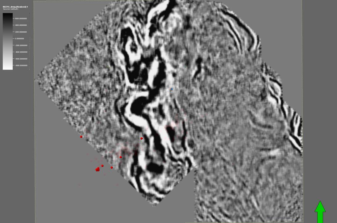
Amplitude images (both vertical and depth slices) extracted from 3D seismic reflection survey over area of Walker Ranch area (adjacent to Raft River). Crossline spacing of 660 feet and inline of 165 feet using a Vibroseis source. Processing included depth migration. Micro-earthquake hypocenters on images. Stratigraphic information and nearby well tracks added to images. Images are embedded in a Microsoft Word document with additional information. Exact location and depth restricted for proprietary reasons. Data collection and processing funded by Agua Caliente. Original data remains property of Agua Caliente.
Citation Formats
TY  - DATA
AB  - Amplitude images (both vertical and depth slices) extracted from 3D seismic reflection survey over area of Walker Ranch area (adjacent to Raft River). Crossline spacing of 660 feet and inline of 165 feet using a Vibroseis source. Processing included depth migration. Micro-earthquake hypocenters on images. Stratigraphic information and nearby well tracks added to images. Images are embedded in a Microsoft Word document with additional information. Exact location and depth restricted for proprietary reasons. Data collection and processing funded by Agua Caliente. Original data remains property of Agua Caliente.
AU  - J., Robert
DB  - Geothermal Data Repository
DP  - Open EI | National Renewable Energy Laboratory
DO  - 10.15121/1287545
KW  - geothermal
KW  - 3D seismic reflection
KW  - Walker Ranch
KW  - Raft River
KW  - 3D seismic
KW  - depth slice
KW  - Narrows
KW  - meq
KW  - microseismicity
KW  - geophysics
KW  - egs
KW  - narrows zone
KW  - active source
LA  - English
DA  - 2016/03/01
PY  - 2016
PB  - Lawrence Livermore National Laboratory
T1  - Walker Ranch 3D Seismic Images
UR  - https://doi.org/10.15121/1287545
ER  -
J., Robert. Walker Ranch 3D Seismic Images. Lawrence Livermore National Laboratory, 1 March, 2016, Geothermal Data Repository. https://doi.org/10.15121/1287545.
J., R. (2016). Walker Ranch 3D Seismic Images. [Data set]. Geothermal Data Repository. Lawrence Livermore National Laboratory. https://doi.org/10.15121/1287545
J., Robert. Walker Ranch 3D Seismic Images. Lawrence Livermore National Laboratory, March, 1, 2016. Distributed by Geothermal Data Repository. https://doi.org/10.15121/1287545
@misc{GDR_Dataset_833,
title = {Walker Ranch 3D Seismic Images},
author = {J., Robert},
abstractNote = {Amplitude images (both vertical and depth slices) extracted from 3D seismic reflection survey over area of Walker Ranch area (adjacent to Raft River). Crossline spacing of 660 feet and inline of 165 feet using a Vibroseis source. Processing included depth migration. Micro-earthquake hypocenters on images. Stratigraphic information and nearby well tracks added to images. Images are embedded in a Microsoft Word document with additional information. Exact location and depth restricted for proprietary reasons. Data collection and processing funded by Agua Caliente. Original data remains property of Agua Caliente.},
url = {https://gdr.openei.org/submissions/833},
year = {2016},
howpublished = {Geothermal Data Repository, Lawrence Livermore National Laboratory, https://doi.org/10.15121/1287545},
note = {Accessed: 2025-07-25},
doi = {10.15121/1287545}
}
https://dx.doi.org/10.15121/1287545
Details
Data from Mar 1, 2016
Last updated Feb 22, 2018
Submitted Jul 17, 2016
Organization
Lawrence Livermore National Laboratory
Contact
Robert J. Mellors
924.423.0578
Authors
Keywords
geothermal, 3D seismic reflection, Walker Ranch, Raft River, 3D seismic, depth slice, Narrows, meq, microseismicity, geophysics, egs, narrows zone, active sourceDOE Project Details
Project Name Identifying High Potential Well Targets with 3D Seismic and Mineralogy
Project Lead Eric Hass
Project Number FY16 AOP 3.1.1.2